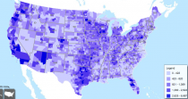
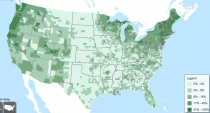
Atlas or Rural Small Town America from USDA ERS
The Atlas of Rural and Small-Town America is a great mapping application that provides a spatial interpretation of U.S. county-level, economic and social conditions along four broad categories of socioeconomic factors: people (using newly released demographic data from the American Community Survey, including age, race and ethnicity, migration and immigration, education, household size and family composition), jobs (using economic data from the
Bureau of Labor Statistics and other sources, including information on employment trends, unemployment, industrial composition, and household income), agriculture (using indicators from the 2007 Census of Agriculture, including number and size of farms, operator characteristics, off-farm income, and government payments), and county classifications (using typologies such as the rural-urban continuum, economic dependence, persistent poverty, population loss, and other ERS county codes). Maps are interactive and also provided for download; raw data are provided for download.
A really fun, interesting, and sometimes surprising application to play around with!


 Your Privacy Choices
Spot on with this write-up, I seriously believe that this website needs
much more attention. I’ll probably be back again to read through more, thanks for the information!